写在前面:没有进行非常难的代码编写,仅仅是算法思想的抽象实现
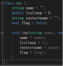
街道模型car类
由于我对matlab的了解很少,所以这里采用vs c++实现的街道模型,主要有三个类
首先是car类,是对街道上的车辆和车流浪进行的模拟,包含的元素有
车辆的名称,或者说ID,用来指代车辆,
当前的车流量,陷于代码能力,目前只能用一个定值来表示,后续可以通过函数的方式,实现一个变量的效果
contectname,用来表示想要和谁建立连接
以及flag,用来表示当前状态,是否建立连接等等
属性后续可以继续加入,以达到更加仿真的模型
街道模型node类
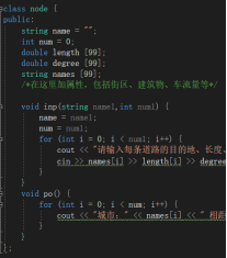
然后是node类,用来表示地图中的城市,包含的元素有
城市的名称,或者说ID,用来指代城市,
与城市相连的城市数目
每条道路的长度
每条道路的角度
每条道路的名称
属性后续可以继续加入,以达到更加仿真的模型
街道模型map类
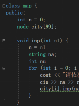
然后是map类,用来表示地图,包含的元素有
城市的数量
以及每个城市
后续可以加入城市的分区、程序的大小之类的属性
c++代码
#include <iostream>
#include "string.h"
using namespace std;

class nodecar {
	string name = "";
	string contectname = "";

};

class car {
	string name = "";
	double liuliang = 0;
	string contectname = "";
	bool flag = false;

	void inp(string name1, double ll, string cname, bool flag1) {
		name = name1;
		liuliang = ll;
		contectname = cname;
		flag = flag1;
	}
};

class node {
public:
	string name = "";
	int num = 0;
	double length [99];
	double degree [99];
	string names [99];
	/*在这里加属性,包括街区、建筑物、车流量等*/

	void inp(string name1,int num1) {
		name = name1;
		num = num1;
		for (int i = 0; i < num1; i++) {
			cout << "请输入每条道路的目的地、长度、角度" << endl;
			cin >> names[i] >> length[i] >> degree[i];
		}
	}
	void po() {
		for (int i = 0; i < num; i++) {
			cout << "城市:" << names[i] << " 相距:" << length[i] << " 角度为:" << degree[i] << endl;
		}
	}
};

class map {
public:
	int n = 0;
	node city[99];

	void inp(int n1) {
		n = n1;
		string na;
		int nu;
		for (int i = 0; i < n; i++) {
			cout << "请依次输入城市和与之相连的个数" << endl;
			cin >> na >> nu;
			city[i].inp(na, nu);
		}
	}

	void cou() {
		for (int i = 0; i < n; i++) {
			cout << "城市" << city[i].name;
			cout << "与以下城市相连" << endl;
			city[i].po();
			cout << endl;
		}
	}
};

int main()
{
	map m;
	int nc = 0;
	cout << "请输入城市个数" << endl;
	cin >> nc;
	m.inp(nc);
	m.cou();
	return 0;
}