环境说明
- Tomcat 8.5.39
- Geoserver 2.13.4 war
- openlayers 4.5.6
- WFS 1.1.0
过程
war通过Tomcat发布的,之前尝试过直接使用war包里面的web.xml进行跨域配置,但是会报内存溢出的错误,所以直接配置Tomcat进行跨域。
1. tomcat跨域设置
在tomcat目录中conf/web.xml约459行下增加:
	<filter>
		  <filter-name>CorsFilter</filter-name>
		  <filter-class>org.apache.catalina.filters.CorsFilter</filter-class>
		  <init-param>
				<param-name>cors.allowed.origins</param-name>
				<param-value>*</param-value>
		  </init-param>
	</filter>
	<filter-mapping>
		  <filter-name>CorsFilter</filter-name>
		  <url-pattern>/*</url-pattern>
	</filter-mapping>
实现跨域。
2. geoserver发布矢量数据
参考geoserver发布shp格式地图
不需要其他多余设置,默认设置就可以达到目的(暂时不考虑,数据读取权限问题)。
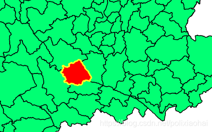
3. 点击查询主要代码
//增加点击高亮的矢量图层
var layer = new ol.layer.Vector({
            source: new ol.source.Vector(),
            style: new ol.style.Style({
                fill: new ol.style.Fill({
                    color: "#f00"
                }),
                stroke: new ol.style.Stroke({
                    color: "#ffff00",
                    width: 3
                })
            })
        });
//加载WMS地图
        var tiled = new ol.layer.Tile({
            source: new ol.source.TileWMS({
                url: 'http://localhost:8080/geoserver/gis/wms',
                params: {
                    'FORMAT': "image/png",
                    'VERSION': '1.1.1',
                    tiled: true,
                    "STYLES": '',
                    "LAYERS": 'gis:county_area',
                    "exceptions": 'application/vnd.ogc.se_inimage',
                    tilesOrigin: 97.52911400949601 + "," + 21.144672509331322
                }
            })
        });
//构建地图
        var map = new ol.Map({
            target: "map",
            layers: [tiled, layer],
            view: new ol.View({
                center: [100.23, 23.15],
                zoom: 5,
                projection: "EPSG:4326"
            })
        })
//点击事件
        map.on('click', function(e) {
            // 创建一个请求
            var featureRequest = new ol.format.WFS().writeGetFeature({
                srsName: 'EPSG:4326', //坐标系
                featureNS: 'http://localhost:7080/gis', // 注意这个值必须为创建工作区时的命名空间URI
                featurePrefix: 'gis', //工作区的名称
                featureTypes: ['county_area'], //所要访问的图层
                maxFeatures: 1,
                outputFormat: 'application/json',
                //这里注意,ol4.5.6里面ol.format.filter.Intersects构造出来的WFS是1.1.0版本,这里的坐标中经纬度是反的
                filter: new ol.format.filter.Intersects("the_geom", new ol.geom.Point([e.coordinate[1], e.coordinate[0]]), "EPSG:4326")
            });

            // 发送请求
            fetch('http://localhost:8080/geoserver/wfs', {
                method: 'POST',
                body: new XMLSerializer().serializeToString(featureRequest)
            }).then(function(response) {
                return response.json();
            }).then(function(re) {
                var feas = new ol.format.GeoJSON().readFeatures(re);
                layer.getSource().clear();
               layer.getSource().addFeatures(feas)
                    // feas = feas.map(function(a) {
                    //     return new ol.Feature({
                    //         geometry: a.getGeometry().clone()
                    //     })
                    // })
                    // layer.getSource().addFeatures(feas)
                    // layer.getSource().dispatchEvent("addfeature")
            });
        })
4. 效果图