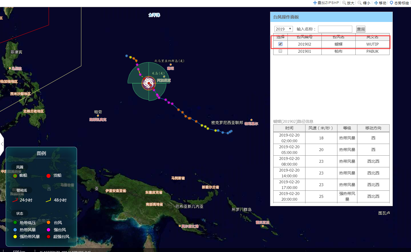
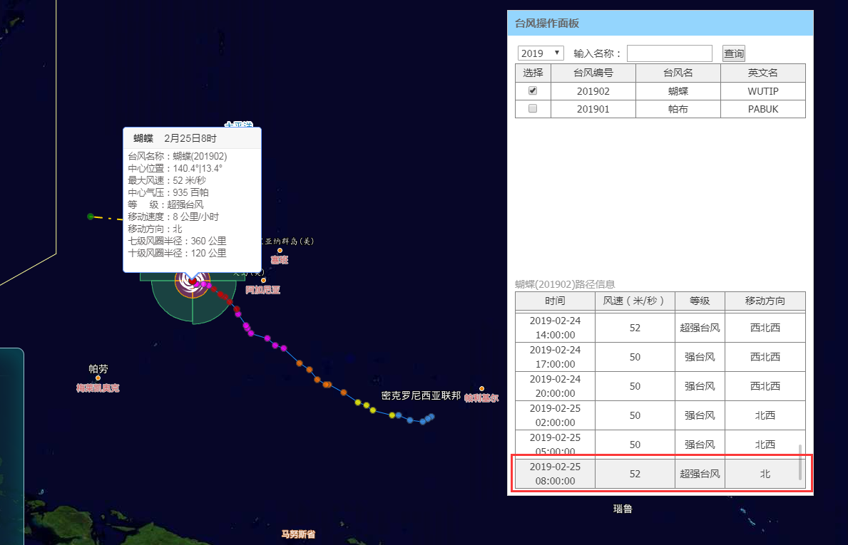
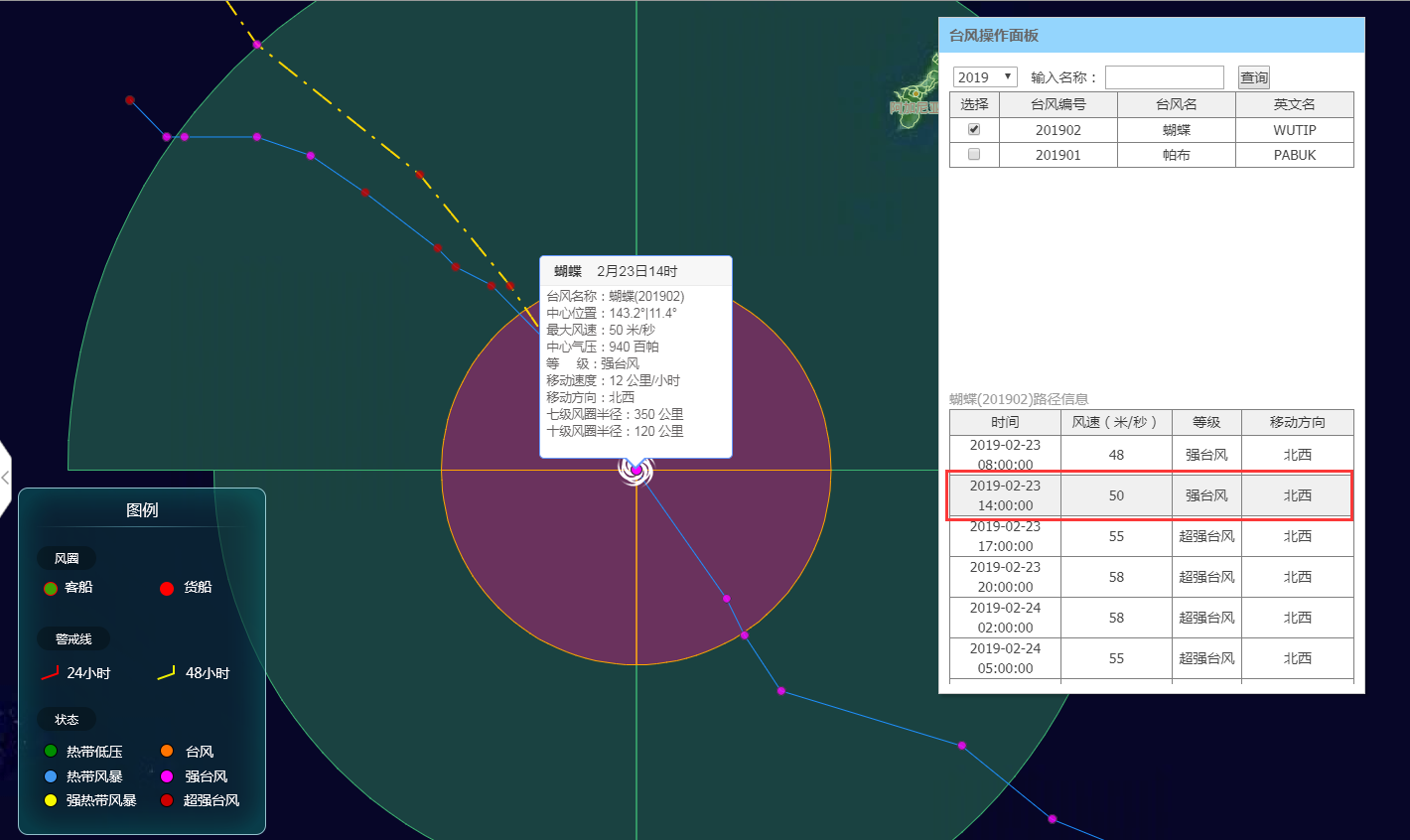
本篇的重点内容是利用openlayers实现台风轨迹功能,效果图如下: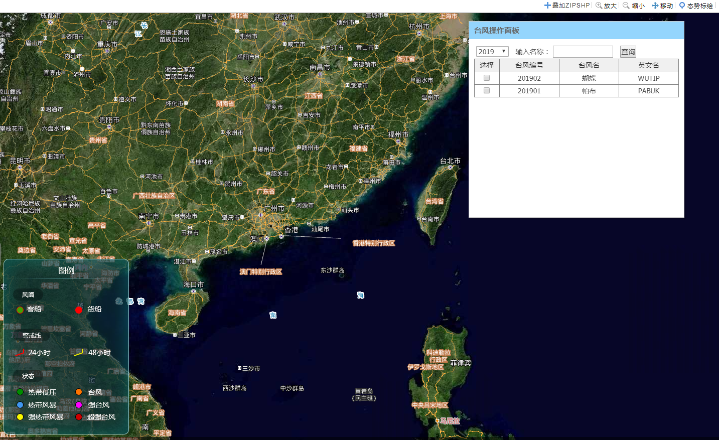
台风轨迹效果图:
实现思路
- 界面设计
//台风
 "<div style='height:25px;background:#30A4D5;margin-top:10px;width: 98%;margin-left: 3px;float: left;'>" +
           "<span style='margin-left:5px;font-size: 13px;color:white;'>台风</span>" +
      "</div>" +
     '<div id="typhoonLayer" style="padding:5px;float: left;">' +
          '<input type="checkbox" name="typhoonlayer" style="width: 15px;height: 15px;vertical-align: middle;margin: auto;"/>' +
          '<label style="font-weight: normal;vertical-align: middle;margin: auto;">台风</label>' +
'</div>'
- 点击事件
 //台风
$("#typhoonLayer input").bind("click", function () {
            if (this.checked) {
                listDialog = new bxmap.TyphoonListDialog();
                listDialog.setTyphoonMap(bmap);
                listDialog.show();
                var map = bmap.getMap();
                map.getView().setCenter([13286590.004642466, 2562780.6843453925]);
                map.getView().setZoom(6);
                //图例面板显示
                $("#map_tl").css("display","block");
                $("#map_tl>img").attr('src', GLOBAL.domainResource+"/Content/img/typhoonLegend.png");
                $("#map_tl>img").css("width","auto");
                $("#map_tl>img").css("height","350px");
            }
            else {
                if(listDialog){
                    listDialog.close();
                }
                //图例面板隐藏
                $("#map_tl").hide();
            }
})
- 台风轨迹初始化
/**
 * @description 初始化图层
 * @param bmap
 * @private
 */
bxmap.Typhoon.prototype._initializeLayers = function () {
    //24小时48小时警戒线
    this.picketLineLayer = new bxmap.layer.Vector({
        source: new ol.source.Vector()
    });
    //台风实际路线节点
    this.realNodesLayer = new bxmap.layer.Vector({
        source: new ol.source.Vector(),
        property: "symbol",
        style: null,
        context: function (feature) {
            return feature["symbol"];
        }
    });
    var symbolizer = new bxmap.symbol.UniqueValueSymbolizer();
    var styles = this.styles;
    symbolizer.addRule({ruleName: "default", styles: styles["TyphoonNodes_Unselected"]});
    symbolizer.addRule({ruleName: "selected", styles: styles["TyphoonNodes_Selected"]});
    symbolizer.addRule({ruleName: "unselected", styles: styles["TyphoonNodes_Unselected"]});
    this.realNodesLayer.setSymbolizer(symbolizer);

    //台风预测路线节点
    this.forecastNodesLayer = new bxmap.layer.Vector({
        source: new ol.source.Vector(),
        property: "symbol",
        style: null,
        context: function (feature) {
            return feature["symbol"];
        }
    });
    symbolizer = new bxmap.symbol.UniqueValueSymbolizer();
    symbolizer.addRule({ruleName: "default", styles: styles["TyphoonNodes_Unselected"]});
    symbolizer.addRule({ruleName: "selected", styles: styles["TyphoonNodes_Selected"]});
    symbolizer.addRule({ruleName: "unselected", styles: styles["TyphoonNodes_Unselected"]});
    this.forecastNodesLayer.setSymbolizer(symbolizer);


    //其他数据
    this.resourceLayer = new bxmap.layer.Vector({
        source: new ol.source.Vector()
    });
}
- 台风轨迹样式设置代码
/**
 * @description 创建样式
 * @return {JSON}
 */
bxmap.Typhoon.prototype.createStyles = function () {
    var output = {};
    //台风节点
    output["TyphoonNodes_Unselected"] = {
        "热带低压": new ol.style.Style({
            image: new ol.style.Icon({opacity: 0.8, scale: 0.8, src: bxmap.Resource.TyphoonPngRddy})
        })
        ,"热带风暴": new ol.style.Style({
            image: new ol.style.Icon({opacity: 0.8, scale: 0.8, src: bxmap.Resource.TyphoonPngRdfb})
        })
        ,"强热带风暴": new ol.style.Style({
            image: new ol.style.Icon({opacity: 0.8, scale: 0.8, src: bxmap.Resource.TyphoonPngQrdfb})
        })
        ,"台风": new ol.style.Style({
            image: new ol.style.Icon({opacity: 0.8, scale: 0.8, src: bxmap.Resource.TyphoonPngTf})
        })
        ,"强台风": new ol.style.Style({
            image: new ol.style.Icon({opacity: 0.8, scale: 0.8, src: bxmap.Resource.TyphoonPngQtf})
        })
        ,"超强台风": new ol.style.Style({
            image: new ol.style.Icon({opacity: 0.8, scale: 0.8, src: bxmap.Resource.TyphoonPngCqtf})
        })
    };
    output["TyphoonNodes_Selected"] = {
        "热带低压": new ol.style.Style({
            image: new ol.style.Icon({opacity: 1, scale: 1, src: bxmap.Resource.TyphoonPngRddy})
        })
        ,"热带风暴": new ol.style.Style({
            image: new ol.style.Icon({opacity: 1, scale: 1, src: bxmap.Resource.TyphoonPngRdfb})
        })
        ,"强热带风暴": new ol.style.Style({
            image: new ol.style.Icon({opacity: 1, scale: 1, src: bxmap.Resource.TyphoonPngQrdfb})
        })
        ,"台风": new ol.style.Style({
            image: new ol.style.Icon({opacity: 1, scale: 1, src: bxmap.Resource.TyphoonPngTf})
        })
        ,"强台风": new ol.style.Style({
            image: new ol.style.Icon({opacity: 1, scale: 1, src: bxmap.Resource.TyphoonPngQtf})
        })
        ,"超强台风": new ol.style.Style({
            image: new ol.style.Icon({opacity: 1, scale: 1, src: bxmap.Resource.TyphoonPngCqtf})
        })
    };

    return output;
}
- 绘制默认警戒线
/**
 * @description 绘制默认警戒线
 */
bxmap.Typhoon.prototype.drawDefaultPicketLine = function () {
    //警戒线数据
    var picketLine24 = '';
    var picketLine48 = '';
    if(this.isProjected){
        picketLine24 = 'LINESTRING(14137575.3307 4028802.0261, 14137575.3307 2391878.5879, 12245143.9873 1689200.1396)';
        picketLine48 = 'LINESTRING(14694172.7847 4028802.0261, 14694172.7847 1689200.1396, 11688546.5333 0)';
    }else {
        picketLine24 = 'LINESTRING(127 34, 127 21, 110 15)';
        picketLine48 = 'LINESTRING(132 34, 132 15, 105 0)';
    }
    var WKTReader = new ol.format.WKT();
    var feature24 = WKTReader.readFeature(picketLine24);
    var feature48 = WKTReader.readFeature(picketLine48);

    feature24.setStyle(new ol.style.Style({
        stroke:  new ol.style.Stroke({
            color: '#ff0000',
            width: 1
        })
    }));

    feature48.setStyle(new ol.style.Style({
        stroke:  new ol.style.Stroke({
            color: '#ffff99',
            width: 1
        })
    }));

    this.picketLineLayer.getSource().addFeatures([feature24, feature48]);
}
- 设置风圈
/**
 * @description 设置风圈
 * @param node - {JSON} 格式{"WD":"20.9","JD":"116.2","EN7Radii":"220","ES7Radii":"220","WS7Radii":"260","WN7Radii":"240","EN10Radii":"50","ES10Radii":"80","WS10Radii":"80","WN10Radii":"50"}
 */
bxmap.Typhoon.prototype.setWindCircle = function (node) {
    if(node == null) return;

    var n = node;
    var center = [n.X,n.Y];
    //台风位置
    this._typhoonFeature.setGeometry(new ol.geom.Point([Number(center[0]),Number(center[1])]));

    //7级风圈
    if(n.EN7Radii){
        var path = this.getSectorPoints(center, n.EN7Radii,0,90,30);
        this._windEN7.setGeometry(new ol.geom.Polygon([path]));
    }else{
        this._windEN7.setGeometry(null);
    }
    if(n.ES7Radii){
        var path = this.getSectorPoints(center, n.ES7Radii,90,180,30);
        this._windES7.setGeometry(new ol.geom.Polygon([path]));
    }else{
        this._windES7.setGeometry(null);
    }
    if(n.WS7Radii){
        var path = this.getSectorPoints(center, n.WS7Radii,180,270,30);
        this._windWS7.setGeometry(new ol.geom.Polygon([path]));
    }else{
        this._windWS7.setGeometry(null);
    }
    if(n.WN7Radii){
        var path = this.getSectorPoints(center, n.WN7Radii,270,360,30);
        this._windWN7.setGeometry(new ol.geom.Polygon([path]));
    }else{
        this._windWN7.setGeometry(null);
    }
    //10级风圈
    if(n.EN10Radii){
        var path = this.getSectorPoints(center, n.EN10Radii,0,90,30);
        this._windEN10.setGeometry(new ol.geom.Polygon([path]));
    }else{
        this._windEN10.setGeometry(null);
    }
    if(n.ES10Radii){
        var path = this.getSectorPoints(center, n.ES10Radii,90,180,30);
        this._windES10.setGeometry(new ol.geom.Polygon([path]));
    }else{
        this._windES10.setGeometry(null);
    }
    if(n.WS10Radii){
        var path = this.getSectorPoints(center, n.WS10Radii,180,270,30);
        this._windWS10.setGeometry(new ol.geom.Polygon([path]));
    }else{
        this._windWS10.setGeometry(null);
    }
    if(n.WN10Radii){
        var path = this.getSectorPoints(center, n.WN10Radii,270,360,30);
        this._windWN10.setGeometry(new ol.geom.Polygon([path]));
    }else{
        this._windWN10.setGeometry(null);
    }
}
/**
 * @description 逆时针计算扇形风圈的点集合
 * @param center - {Array<String|Number>}中心点,例如[117.23,23.123]
 * @param radius - {String|Number} 半径km
 * @param startAngle - {String|Number} 起始角度(单位°)
 * @param endAngle - {String|Number} 结束角度(单位°)
 * @param pointNum - {String|Number} 返回构成的弧点个数,默认30
 * @return {Array}
 */
bxmap.Typhoon.prototype.getSectorPoints = function(center,radius,startAngle,endAngle,pointNum) {
    radius = Number(radius) * 1000;

    if(!this.isProjected){
        var MetersPerUnit = 111319.49079327358; //1度多少米
        radius = radius/MetersPerUnit;//转化为度
    }
    center = [Number(center[0]),Number(center[1])];
    startAngle = Number(startAngle);
    endAngle = Number(endAngle);
    pointNum = Number(pointNum || 30);

    var sin;
    var cos;
    var x;
    var y;
    var angle;
    var points = new Array();
    var pointsLL = new Array();
    var lonlat = center;
    points.push([center[0], center[1]]);
    for (var i = 0; i <= pointNum; i++) {
        angle = startAngle + (endAngle - startAngle) * i / pointNum;
        sin = Math.sin(angle * Math.PI / 180);
        cos = Math.cos(angle * Math.PI / 180);
        x = center[0] + radius * sin;
        y = center[1] + radius * cos;

        points[i + 1] = [x, y];
    }
    points.push([center[0], center[1]]);
    for (var j = 0; j < points.length; j++) {
        pointsLL[j] = points[j];
    }

    return pointsLL;
}