During the "14th Five-Year Plan" period, the state attached great importance to issues such as soil ecological environment monitoring, and successively issued a series of normative documents, establishing a set of standards, guidelines, guidelines and management countermeasures for the field of soil control in my country, so that my country's soil Restoration laws and regulations and standardized construction have shown a trend of serialization and systematization, effectively preventing and controlling soil environmental risks.
Soil Moisture Monitoring System
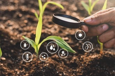
As a large agricultural country, in the face of farmland drought and water-saving irrigation, how to accurately and effectively analyze soil moisture and prescribe the right medicine in time is one of the key tasks of modern agriculture.
In order to better serve the needs of modern agriculture, Zhentu Information uses the self-developed ZTMap3DGIS system engine, combined with new information technology applications such as the Internet of Things, big data, artificial intelligence, and digital twins, to build a complete set of wisdom with soil moisture monitoring equipment. The agricultural service visualization platform empowers agricultural production and management in soil moisture analysis with grid-based zoning management and refined data monitoring, and provides important decision-making support.

The smart agricultural soil moisture monitoring system will dynamically monitor and provide real-time feedback on soil moisture in the fields of geographic information distribution, video surveillance, intelligent monitoring, soil data analysis, environmental monitoring, disaster warning, etc., and accelerate the rapid development of intelligent modern agriculture.
System functions
1. Distribution of geographical information
The large-screen visualization platform based on the ZTMapGIS geographic information system can accurately grasp the regional soil moisture information and its spatial distribution pattern, which plays an important reference value for the analysis of soil moisture data.

Based on the ZTMapGIS geographic information engine, relying on the distribution characteristics and laws of land spatial management, a soil monitoring data interface control scene in satellite/map mode is constructed. At the same time, the system page can intuitively display the geographic location information of all current monitoring sites, and users can easily confirm the location of monitoring sites through online search.
2. Real-time online monitoring
The large ZTMap visual screen can realize the monitoring and viewing of the dispatching center. Through sensors, cameras and other equipment, it can sort out the dynamic details of crop growth and natural disasters and other data 24 hours a day, and monitor temperature and humidity, sunshine value, air quality, soil moisture, pests and diseases, etc. in real time. parameter value.

The system can also superimpose remote sensing monitoring layers, select different time periods, and analyze the soil moisture in real time according to the growth of crops, providing intuitive basis for agricultural managers to grasp the actual situation, make scientific decisions, and rationally plan farming. utilization rate.
3. Intelligent monitoring and early warning
The overall interface of the smart agricultural soil detection system platform will use remote sensing technology to obtain 3D visualization scene information on the ground to form a lightweight 3D model of 3D data and visual image data, and through the combination of sensors and monitoring equipment, the dynamic information of crop growth can be remotely monitored and automatically identified. Soil moisture parameters.

Set the safety range threshold for soil moisture monitoring parameters. Once the sensor detects a certain data abnormality, the system will automatically push the alarm information. The user administrator receives the alarm information through the mobile terminal or the large visual screen, and promptly arrives at the alarm location for processing. Minimize impact. At the same time, it can effectively solve the problems of time-consuming, laborious, untimely and inaccurate manual statistical data, and greatly improve work efficiency and timeliness of soil moisture management.
4. Data Analysis and Query
The system uses 24-hour real-time data monitoring equipment to realize online collection of parameter information and automatically generate data charts. Users can intuitively understand the ecological environment changes of soil moisture. The soil moisture collected by the system can be saved as historical records through the background and viewed and exported at any time, so as to facilitate intuitive analysis of soil moisture data.
Summarize
Overall, improving monitoring efficiency is one of the keys to the rapid development of modern agriculture. Zhentu Information uses big data to pave the way for the most important underlying data for the development of agricultural modernization, to ensure that managers can accurately record the details of soil moisture at each stage of planting crops, and to ensure the authenticity and effectiveness of soil sampling and monitoring. Through the standardized soil sampling process, the land utilization rate is greatly improved, and it provides users with full-cycle application services such as soil data monitoring basis, testing standards, testing specifications, data management and visual display.
Zhentu Information actively responds to the national call for standards, and uses information technology to build a soil moisture system platform for full-cycle management, which effectively improves the level of intelligence and automation of agriculture, and greatly improves the land utilization rate of farmland and agricultural productivity. The public provides information services, provides information-based decision-making basis for agricultural production management, and helps the development of modern agriculture.