系列链接:
Java web与web gis学习笔记(一)——Tomcat环境搭建
Java web与web gis学习笔记(二)——百度地图API调用
JavaWeb和WebGIS学习笔记(三)——GeoServer 发布shp数据地图
JavaWeb和WebGIS学习笔记(四)——使用uDig美化地图,并叠加显示多个图层
前言:在上一篇博客JavaWeb和WebGIS学习笔记(四)——使用uDig美化地图,并叠加显示多个图层中,我们使用Layer Preview功能,通过GeoServer自带的OpenLayer预览到了我们发布的地图。预览时的url通常是很长一串字符。
这种方式虽然也能够进行访问,但预览的URL包含了大量请求参数,直接提供这样一个URL链接既不方便访问,也有碍观瞻。因此,我们何不自己使用OpenLayers在自己的网页中显示发布的地图呢。
OpenLayers 是一个专为Web GIS 客户端开发提供的JavaScript 类库包,用于实现标准格式发布的地图数据访问。它 支持Open GIS 协会制定的WMS(Web Mapping Service)和WFS(Web Feature Service)等网络服务规范。可以在浏览器中帮助开发者实现地图浏览的基本效果,比如放大(Zoom In)、缩小(Zoom Out)、平移(Pan)等常用操作之外,还可以进行选取面、选取线、要素选择、图层叠加等不同的操作,甚至可以对已有的OpenLayers 操作和数据支持类型进行扩充,为其赋予更多的功能。
一、引入OpenLayers
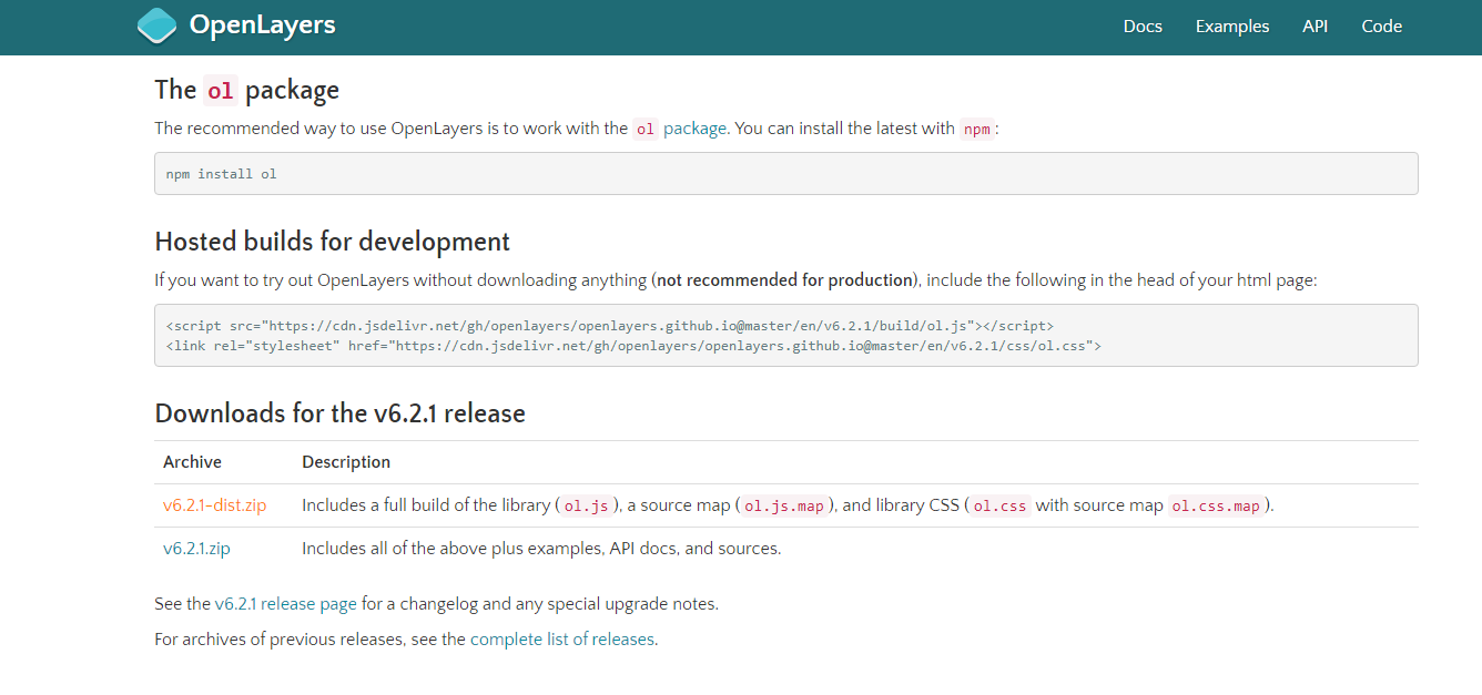
OpenLayers的引入方法有三种。这里是官网openlayers下载地址的介绍
-
使用npm安装OpenLayers
npm install ol -
在网页中引入在线地址
<script src="https://cdn.jsdelivr.net/gh/openlayers/openlayers.github.io@master/en/v6.2.1/build/ol.js"></script> <link rel="stylesheet" href="https://cdn.jsdelivr.net/gh/openlayers/openlayers.github.io@master/en/v6.2.1/css/ol.css"> -
将OpenLayers下载到本地,并引入
二、使用OpenLayers显示地图
关于OpenLayers的使用,官方文档已经很详尽了,也有很多具体的例子。
可以先参考这个openlayers quick start做一个简单的入门。
具体使用到的内容可以参考官方API文档。
显示地图需要Layer Source WMS服务的URL,通过GeoServer中的Layer Preview可查看到预览时的URL
http://localhost:8080/geoserver/xjs/wms?service=WMS&version=1.1.0&request=GetMap&layers=xjs%3ABoundaryChn2_4p&bbox=73.44696044921875%2C6.318641185760498%2C135.08583068847656%2C53.557926177978516&width=768&height=588&srs=EPSG%3A4326&format=application/openlayers
不难看出,WMS服务的URL是:
http://localhost:8080/geoserver/工作区名称/wms
如果需要公网访问,则对应URL就是:
http://ip:port/geoserver/工作区名称/wms
其中ip是云服务器的公网ip,port是开放的端口,工作区名称即为你的数据源所在工作区。
这里给出显示地图的全部代码:
<!doctype html>
<html lang="en">
<head>
<meta http-equiv="content-type" content="text/html" charset="UTF-8"/>
<link rel="stylesheet" href="oldist/openlayers/ol.css" type="text/css">
<style>
#map {
clear: both;
position: relative;
height: 800px;
width: 100%;
}
#loaction{
float:right;
}
</style>
<script type="text/javascript" src="oldist/openlayers/ol.js"></script>
<script type="text/javascript" src="http://apps.bdimg.com/libs/jquery/1.6.4/jquery.js"></script>
<title>olmap</title>
</head>
<body>
<div id = mapbox>
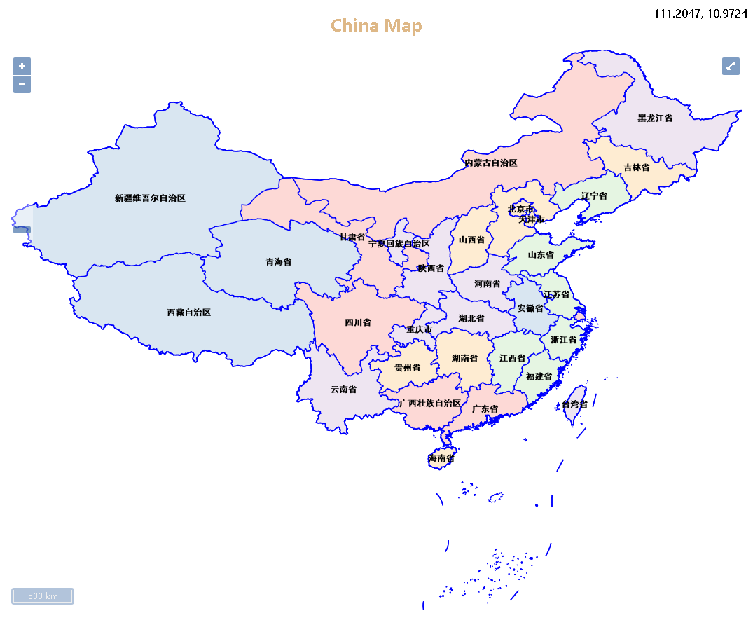
<h2 style="color:burlywood;text-align: center;">China Map</h2>
<div id="map" class="map"></div>
</div>
<div id="wrapper">
<div id="location"></div>
</div>
<script type="text/javascript">
var envstr = '';
var urlAdr = 'http://localhost:8080/geoserver/xjs/wms'; //根据自己的需要更改ip和port
var layerName = 'xjs:BoundaryChn2_4p,xjs:BoundaryChn2_4l,xjs:BoundaryChn1_4l'; //改变图层名
var tiled;
var untiled;
$(function(){
//设置地图范围
var extent = [73.44696044921875,6.318641185760498,135.08583068847656,53.557926177978516];
var envstr = 'color'
//图像图层
untiled = new ol.layer.Image({
visible:true,
source: new ol.source.ImageWMS({
ratio: 1,
url: urlAdr,
params: {
"LAYERS": layerName,
'TILED': false,
},
serverType: 'geoserver'
})
});
//定义图层数组
tiled = new ol.layer.Tile({
visible:false,
source: new ol.source.TileWMS({
url: urlAdr, //WMS服务URL
params: { //请求参数
'LAYERS': layerName,
'TILED': true,
},
serverType: 'geoserver'
})
});
var maplayers = [untiled,tiled];
//定义地图对象
var map = new ol.Map({
layers: maplayers,
target: 'map',
view: new ol.View({
projection: 'EPSG:4326',
//center: [115, 39],
//zoom: 5
}),
controls: ol.control.defaults({
attributionOptions: {
collapsible: true
}
})
})
//自适应地图view
map.getView().fit(extent, map.getSize());
//添加比例尺控件
map.addControl(new ol.control.ScaleLine());
//添加缩放滑动控件
map.addControl(new ol.control.ZoomSlider());
//添加全屏控件
map.addControl(new ol.control.FullScreen());
//添加鼠标定位控件
map.addControl(new ol.control.MousePosition({
undefinedHTML: 'outside',
projection: 'EPSG:4326',
target:$("#location")[0],
coordinateFormat: function(coordinate) {
return ol.coordinate.format(coordinate, '{x}, {y}', 4);
}
})
);
})
</script>
</body>
</html>